Whatever the weather: precipitation variability on Catalina
Before Avalon was officially a city, before many cars were on the island and while locals were still predominately traversing the hills in horse-drawn carriages, weather data was being collected on Catalina Island. This information, collected for more than a century, provides a long-term record of precipitation on the island.
The second session of Catalina Island Conservancy’s annual symposium, sponsored by the Port of Long Beach, took a closer look at precipitation data over time. Conservation Operations Director Laura Minuto discussed water because of its global – and local – importance.
“Water is an extremely important topic globally and on Catalina precipitation is responsible for replenishing our surface water bodies. It renews our soil moisture which in turn is used by plants, and when there’s enough infiltration it can recharge our aquifers,” she said. “We’re isolated from the mainland. We rely on our own ability to provide fresh water to our inhabitants, both human and flora/fauna. Unlike much of the rest of California we are not able to tap into the complex system of reservoirs, aqueducts, power plants and pumping plants that extend more than two-thirds the length of the state to support our water supply.”
Minuto explained that long-term weather data can be used in several ways.
“We can relate it to observations and trends in plant growth – both native and invasive species and faunal populations. We can understand if precipitation has changed over time. Is it increasing? Is it decreasing? Is it becoming more variable?” She added, “We can also estimate the probability that a drought might occur or an extreme event could happen. We can couple this data with climate models and predict future trends given different scenarios.”
From the long-term data record (the oldest rainfall record of which is from the Avalon Green Pier starting in 1910, thanks to Avalon’s harbor department!), we learn that the majority of Catalina’s rainfall is December through March. We get the highest rainfall in January and February, and our average temperatures are between 54 and 70 degrees Fahrenheit.
A 63-year data set provided more granular takeaways – and lots of graphs. Looking at 1958-2020, we learned that the mean rainfall in Avalon was 11.81 inches, with a minimum of 1.52 inches in 2018 and a maximum of 30.45 inches in 1978; at Airport in the Sky, the mean rainfall was 13.57 inches with a minimum of 3.55 inches in 2007 and a maximum of 31.51 inches in 2005. Moving across the island, Middle Ranch saw a mean of 13.17 inches of rainfall, with a minimum of 3.74 inches in 1961 and a maximum of 34.32 inches in 1995, whereas Two Harbors had the lowest mean rainfall of 9.73 inches, with a minimum of 1.9 inches in 2018 and a maximum of 23.05 inches in 2005.
From a land management perspective, “Catalina experiences substantial variability in precipitation, so managing for the extremes – both the very dry years and the very wet years – can really be a challenge for us,” Minuto said.
It is not so much the total amount of rainfall that causes an issue, but how it happens.
“Not only are Catalina Island rainfall amounts variable annually, it’s also variable in how that rainfall occurs over the year. Note that 12 inches of rainfall in one year isn’t necessarily going to look like the 12 inches in another year – in fact, it probably will not look the same,” she said. “This has implications for how that water is going to be conveyed. Is it going to evaporate? Is it going to infiltrate? Will it run off?”
“That amount of rainfall, soil moisture conditions, topography, vegetative cover, soil type and other climatic factors, coupled with when and how rainfall occurs, is really going to tell us what the water is going to do. For example, if we receive a lot of rainfall in a short period of time, it likely will exceed the soil’s ability to absorb the water and we’ll experience a lot of runoff,” Minuto added. “If we receive many lower intensity but significant storm events paced evenly throughout the year, we may get a lot of recharge into our aquifers. If we have multiple wet years in a row, we will likely see faunal populations bloom and both native and invasive species pop up. And if we have multiple dry years, we might find that the invasive species start out-competing our native plants.”
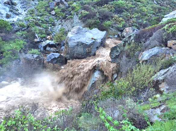
She looked at several extreme events in detail, including several from the very wet year of 2017. At one point in January, due to the precipitation distribution, Little Harbor Campground was essentially underwater. She also looked at Cottonwood crossing around the same time period. In February 2017, Cottonwood went from a small streamflow to a deluge.
“Normally we do not have streamflow going out to the ocean at Cottonwood, but in this case we definitely had a raging river,” Minuto recalled. “It can wipe out your infrastructure when you have these big flows.”
In viewing the example, we see that several very large rain events surrounded and preceded by smaller soaking events are really perfect conditions for some serious flows.
To learn more about Island precipitation and view all of the graphs and examples, watch the full presentation on the Symposium page at catalinaconservancy.org. There is still time to sign up online for the final presentation in the Symposium series this Monday, November 23, which will focus on the diversity of bats on Catalina Island.


